


From FOTAQ ANDREA
Part Two
Memorie.al / It is known that, in the field of cartography, the Albanian lands appeared for the first time on the geographical map of Ptolemy in the 2nd century AD, which provides not only the Illyrian territory between Durrës and Tirana, defined by the term “Albanopoli” as a city of the Albanians, but also attests to other Illyro-Dardanian settlements. Next, it will be the Tabula Peutingeriana, 3rd century (in its segment VIII, named “Iliricum” and “Iepirum”) that will define Illyrian-Albanian lands and territories, such as Scodra, Dyrratio, Apollonia, Aulona, and it will continue further with the map of Al-Idrisi (1154), to reach the 14th-15th centuries, where Arbëresh and Albanian territories begin to appear under the name “Albania”, even their main cities, with their castles, rivers, boundaries, etc. There is no doubt that over the centuries, the profusion of such maps with the term “Albania”, compiled by distinguished European cartographers, marvelously constitutes a wealth and evidence of ancient Albanian ethnicity.
Continued from the previous issue
In the end, even though the use in Albanian of the word hartë (map) instead of the word kartë, which Konica preached, “won”, there is no “loss” in this, nothing “bad”, when it is known that in linguistics, the use of words is a matter of taste, preference, habit, fashion, even “obligation”, as in the case of the massive use of the term shok (comrade) during the totalitarian regime, instead of the word zotëri, zot (sir, master). But we, for our part, have the right to find the Konica phrase “kartë dheshkrimore” (land-writing card) beautiful and striking, which we appreciate, as it sounds sweet to our ears, like a slightly exotic phrase, but which undoubtedly constitutes a masterful Konica invention.
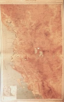
From a technical and topographical point of view, the base map that Konica relied on was, as he himself says, the Map of the Military Geographical Institute of Vienna. “It is the best map that exists for Albania, but it has many inaccuracies,” he says of it. He knew that two editions of that map existed: that of 1880, which the Albanologist Julius Pisko had used to determine – without success – the topography of Skanderbeg’s campaigns, and the more recent one of 1900.
By closely studying these maps, Konica would reach the conclusion that a truly scientific work in the field of cartography should be based, first and foremost, on two basic criteria: a) the work should be done by people from the terrain itself, who know it fundamentally, “people from Tirana, Elbasan, Durrës, Dibra,” he says; b) people dedicated to this work should be taken, who have love and interest for the history of the people and their glorious epics.
As an Albanian with ancient noble roots, full of fiery love and patriotism for his country, and as a top-tier erudite, Konica met and often exceeded these two main criteria. And, as for the history and glorious epics of the Albanian people, Konica had long set his sights on the Skanderbeg epic, to revive the memory of the National Hero and the Albanian national feeling itself.
Because it is known that Konica is the first Rilindas (Renaissance figure) who concretely undertook the study of the topography of Skanderbeg’s campaigns (Albania, no. 9, 1901), precisely the field of study where the Austrian Pisko had failed. Also relying on the studies of J. G. Hahn and Biemmi, Konica gave 16 localities-arenas of Skanderbeg’s battles against the Ottoman sultans, from Albulena, Alkriha, and Çidhna to Mekhadio, Modrisa, Mokri, Oroniqi, Otoneta, Petralba, Svetigrad, Talmirana, Torviolli, Vajkal, etc.
Only he regrets that he did not manage to make sufficient use of his own study to present these campaigns on the map he prepared, as he was satisfied with simply placing some dates below the main historical localities of the map. What particularly interested him were the ethnic and historical borders of Albania. He also knew the Commercial Map of Albania (“with the two Albanias – Tosk and Gheg”) by F. Bianconi, and “with its false errors” (F.K.), when all of Manastir with its Albanian villages had been left outside the borders. “Manastir is an Albanian province as much as can be,” Konica protests with full conviction (Albania, no. 13, May 30, 1898).
Not only that, but in his numerous writings, he often expresses his anger to the point of revolt whenever he refers to historical injustices at the expense of Albanians, starting with the Congress of Berlin that savagely fragmented their lands. Above all, with a powerful polemical tone, he lashes the backs and lands heavy blows on the heads of the chauvinist political circles of neighboring countries – Serbian, Montenegrin, Bulgarian, Greek, Macedonian, and Italian – as well as their spokespersons and penmen, mainly French, who were terribly breathing down the neck of the Albanian nation during the shameful decline of the Ottoman Empire.
In the very first issue of the marvel *Albania* (March 1897 – but prepared as early as 1896), in a “Short Note” of 20 lines, the 20-year-old Konica, taking up Prud’hon’s formula, would write with the pen of a genius an ideological, historical, and patriotic concentrate, writing: “What is the third estate? Nothing. What should it be? Everything.” And, parodying this famous historical formula, to show that the fate of Albanians under Ottoman Turkey was the fate of sub-humans who enjoyed no freedom or independence, but were the main active factor, Konica asks: “What are the Albanians in European Turkey? Nothing. What should they do? Everything”
He continues: “We have no money to pay newspapers and agencies, but we have powerful lungs, and our call will finally reach the general public. Here we are proclaiming loudly, here we are calling forcefully for honest and well-disposed people to listen: The current territories of Greece, Serbia, Bulgaria, and the group of villages called Montenegro include foreign elements; to establish justice, Thessaly, a part of Bulgaria and Montenegro, and Serbia, from Vrana going south, should be attached to Albania.
Instead of behaving themselves, like the thieves they are who have already taken too much, and when they should be filling their pants for fear of losing it, the Greeks and others still want to carve up Albania. To the Greeks and others, we are telling them this moment with a clear voice: enough! Go no further!” – Here, then, is another fantastic Konica à la Wagner! And how current, when today’s Greeks want our sea, pursue the border of Northern Epirus with the invention and placement of Greek soldier cemeteries like a Nastradin nail, when the Greek soldiers themselves have turned into cannibals to eat Albanian flesh, and when the Albanian Autocephaly in the center of Tirana is an empty word.
Finally, if we compare Konica’s 1902 Map with the Map of Natural Albania of 1867, drawn up by F. Milone in 1942, we notice that they have no difference regarding the Albanian lands that today lie beyond the physical borders arbitrarily determined by the Great Powers in 1913 and 1920.
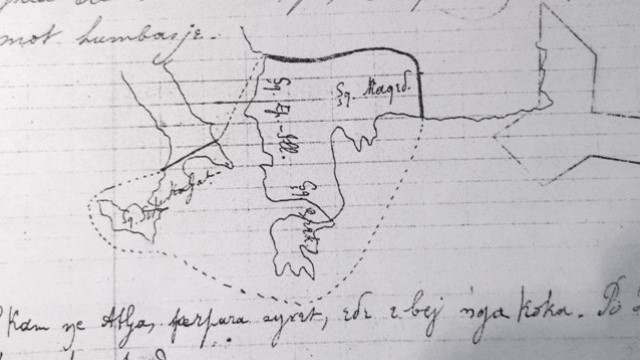
Following the curved line of the names of neighboring places, we notice that the “division” is outlined according to what we would call the “classical line”, which starts from Arta-Preveza in the South, heading towards Kallabaku and Dishkati in the Southeast, further East towards Kozhani, Manastir, and Prilep, climbing towards Kumanovo, Vranja, and Leskovac as the northeasternmost points, culminating in the North towards Ibër and Berona, and ending in the Northwest towards Rrashpa and Ulcinj.
But one thing is striking: at a time when borders have become the most sacred thing, Konica leaves the borders of Albania open, bearing in mind the bitter past of the fragmented and massacred Albanian nation, as a political and historical response to arbitrary European circles, implying that the borders of Albania are wherever Albanians are in their historical lands, Albanians who have resisted violent assimilation and mass expulsions.
On the other hand, this open Albania, with open Konica borders, which also causes neighboring countries not to have defined borders with Albania, appears as a highly current message, coming from Konica’s pen since the beginning of the 20th century, for Balkan and European openness, for what is aimed towards a United Europe. And we cannot help but hold our Faik Konica as a forerunner of the melting of the border ice that historically divides peoples and countries, as a forerunner of a borderless Balkans and Europe.
The First Map of Albania
By Faik Konica
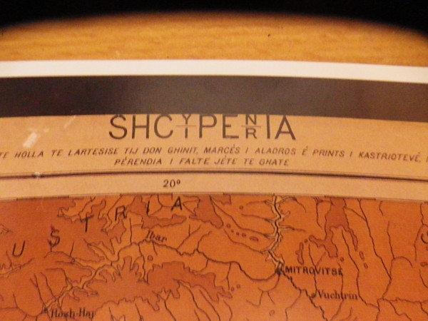
Geographical map of Albania, scale 1:500,000, format 1.20m x 0.75m, drawn up by the Geographical Institute of the New University of Brussels. (Price 2 francs for Albania, 5 francs elsewhere. To receive it not folded, but rolled on cardboard, add 0.50 francs).
The works of the Military Geographical Institute of Vienna served as a basis for our map, but here are the improvements that have been realized:
The names of localities and other features are written in Albanian with precise accuracy.
Elevation contours appear in five different colors, from the lightest brown which becomes stronger, to the darkest bluish, as altitudes are followed, and a single glance at the map is enough to create a clear idea about the configuration of the Albanian land. This method, on the other hand, allows the clever professor to give his students a series of suggestive and attractive lessons, which are impossible with maps where altitudes appear with some vague hatching, elongated here and there.
Because this map is intended primarily for schools. Hence we have used such a large format and, in order to give the names in large, easy-to-read letters, we limited ourselves to a nomenclature of about 400 localities, rivers, lakes, etc. We did not intend to make a map for a narrow field, and the high scientific feeling of Mr. Elisée Reclus would have welcomed these impartial requirements of ours with joy.
There is no dividing line between Albania and neighboring countries, also Turkish [under Turkish suzerainty], but inhabited by other nationalities. We did not want to determine disputed borders. It is a scientific map and nothing more, or rather, nothing less. If we have included parts of clearly non-Albanian territory, for example in the Northeast, it is understood – unless they are narrow-minded to our regret – that it is impossible on a map to cut extreme borders and we would have to use straight lines.
So, we are not causing any ambition, any illusion, even a small one. Those who live on words and rock themselves with wordy lullabies have no reason to come and complain and unleash their usual peacock screams. Likewise, the borders of neighboring countries are not marked with a line, but this, for completely different reasons. Given the scale of our map and the possible inaccuracy of the documents available, we feared inaccuracies.
Therefore, the names of neighboring places were written along a curve, in accordance with the general line of the borders. I think the idea was successful and could not be done better. The country is not divided into vilayets, since this division presents no interest from a geographical point of view. On the contrary, below the names of the main historical localities, some dates are given. It is a pity that we did not manage to make better use in this direction of our study published in Albania under the title Topography of Skanderbeg’s Campaigns.
On the other hand, to increase interest in this admirable map, we added two insets, one on the geology, and the other on the climate of Albania. I feel it as a duty to thank with all my heart, in the name of the Albanian people, Mr. Elisée Reclus, who is not only a great geographer, but also a great heart and who, here as in everything, showed himself with a noble, lofty heart. I also thank Mr. Bertrand and Mr. Pattesson, the two distinguished cartographers of the Institute who took on with so much skill and dexterity to carry this entire enterprise to the end.
Are there material errors on this map? I don’t think so; but it is possible and, in that case, I ask for forgiveness, because everything related to the nomenclature, it is understood, obviously, was provided by me. I put into action my memory and all the books I could, specifically the excellent geography of Albania published by the Jesuit Fathers of Shkodra. And yet, I fear that errors may have been made, especially regarding the North of Albania.
We gratefully welcome all comments that may be made to us; we will classify them and, if this first edition, as we hope, sells out quickly, we will use them for a future edition. In the meantime, without a doubt, the Military Geographical Institute of Vienna will have published its new map of southern Albania, which will likely allow, in our second edition, some changes in the elevation contours.
It would be a lack on my part if I did not fulfill the most important obligation to thank Mr. De Aladro, who bore the expenses of this edition. With the kindest naturalness, he undertook all the expenses, one day when I was telling him about a map project of Albania. Here is a more than useful action, and all Albanians are grateful to him.
F.K.
P.S. The map is on sale at the Albania editorial office and at the Kissling Bookstore, Montagne de la Cour, in Brussels.
Albania, Year 6, April-May 1902, no. 4-5. (The complete maps “Dielli” will publish in the printed issue). / Memorie.al
![“After the ’90s, when I was Chief of Personnel at the Berat Police Station, my colleague I.S. told me how they had once eavesdropped on me at the Malinati spring, where I had said about Enver [Hoxha]…”/ The testimony of the former political prisoner.](https://memorie.al/wp-content/uploads/2024/09/Ndertesa-e-DPB-se-te-Beratit-ku-ne-vitet-70-te-iu-nenshtruan-proçeseve-hetimore-Sokol-Sejko-dhe-pjestaret-e-Grupit-te-Poshnjes.-350x250.jpg)