


By Prof. Dr. Aleksandër Meksi
Memorie.al / It must be acknowledged that we still lack a comprehensive study, along with a high-quality and scientific publication, of the historical maps of Albania from these centuries. This may be because they are scattered in a significant number of libraries and archives, which requires considerable effort and resources. A complete study and publication of them would certainly be useful for historical and historical geography studies of this period.
They are located in the libraries and archives of Venice, Florence, Paris, Milan, Vienna, Parma, Berlin, London, and other countries. Of course, we are talking about those that are found in existing literature and publications, while further research is also needed.
Some time ago, we published data from a map from the 80s-90s of the 10th century by the Arab traveler Ibn-Hawqal, from his book “Kitab surat al ard.” In his depiction of the Adriatic Sea, Butrint (Badhrant) was included alongside Venice and Otranto, which he also mentions in the text of the book. We thus have a very valuable testimony for a very dark period with very little data on the lands inhabited by Albanians.
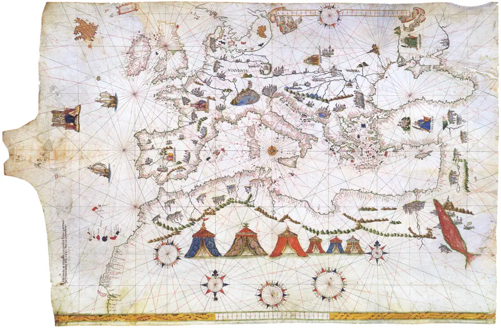
It is already known that during the dark centuries of the Middle Ages, the eastern coast of the Adriatic served as the main travel itinerary through the Adriatic to the Byzantine territories of Venice. This was because the winds were favorable on this coast, there were coves and ports to hide in bad weather, and there were opportunities to be supplied with drinking water. It is understood that sailors had complete information about these territories, and this information was passed from one to another. Portolans are precisely one of the ways of passing this information from one to another.
Unlike nautical charts, which outline coastal points and some inland centers, portolans are a description of the coastline, as much as sailors need, without being equipped with maps. That is, the ports, the way to approach them, their distinction from afar, dangerous shallows near them and at the entrance, water supply locations, and distances from one port to another.
With the publication of medieval Italian portolans by K. Kretschmer and Greek portolans by A. Delatte, it is now possible to study the degree of knowledge of the Albanian coast by medieval sailors, including anchorages, river mouths, capes, water supply locations, coastal castles, and in some cases, even the shallows in front of the harbors, of course, to avoid them.
According to medieval portolans, the Albanian coast begins in the north with Tivarin, continuing south to the vicinity of Butrint, where the distances are given… in miles from one point to another, which are necessary for those traveling along the coast, and for some of them, also from points on the western coast of the Adriatic or the Ionian Sea, for those coming from there. The size of a mile mentioned in these portolans, according to the studies carried out, fluctuates from 1.17 km to 1.41 km. In addition to this, orientations are also given according to the cardinal points of the horizon, to find the way when ships sailed from one port to another.
Below we mention the portolans considered by the authors mentioned above, the reference data for them, and the sigil used by the publisher in each case. We will then give the list of places on the coast of medieval Albania that are mentioned in these portolans, starting from the North to the South.
Italian Portolans:
The fragmented portolan of the Marciana Library in Venice (Marc) is preserved in Codex No. 87 of the library in question. According to Kretschmer, it seems to belong to the end of the 13th century.
Another is the portolan of Pietro Versi (Pietro de Versi) (V), which is preserved in Codex Marcianus chartaceus, Mss. Italiani, Classe IV no. 170, with dimensions of 21 x 14 cm, and is dated to the year 1445.
A separate group is formed by the Magliabecchi Portolans in Parma (Magliabecchi: P, Ma, Mb); the one preserved in the Casanatense Library in Rome (Cas), and the one in the Marucelli Library in Florence, which are generally dated around the middle of the 15th century. From the study of the texts of this family of portolans, it appears that the part that speaks of the Albanian coast is the same in them.
The Portolan of Gratiosus Benincasa (Be), which is preserved in the state archive in Ancona, “Codex chartaceus No. 48”, compiled between the years 1435-1445, is also of value, as well as the Rizo Portolan (Rz) compiled in Venice by Bernardino Rizo in 1490 and preserved in the local Marciana Library (Cl. CIX, Cod 4, No. 40/35).
Greek Portolans:
The publisher of the Greek portolans, Delatte, seeing their similar content, includes them in a family, marking each of them with a special sigil. According to him, they represent Greek sea voyages in the era when Byzantium had given up the sea trade routes to others. In them, many borrowings from the Venetian dialect are visible. They are:
Athens Manuscript (A) which bears the date 1534;
Vienna Manuscript (V) “Histori gr. 82”, dated to the 16th century;
Vienna Manuscript (Ë), “Theol. Gr. 244”, 16th century;
Vatican Manuscript (O), “Ottobonianus gr. 339”, from the end of the 16th century;
Paris Manuscript (P), “Bibliotheque Nationale no. 1416”, from the 16th century, which seems to have been copied from a 15th-century text and
The Greek Portolan (T) published in Venice in the years 1573, 1618, 1641.
Of these, the first is preserved in the Barberini funds of the Vatican, PVIII66, the second in the Angelica funds, BB12, 2; the third in the university library of Leyde, 541 F 12. Their text on pages 24 (v) – 86 (v) is an almost faithful reproduction of the Rizo portolan. The first two texts have praise from Demetrio Tagias for their discovery in 1559.
In these portolans, as we mentioned, many places on the Albanian coast are found, which we are listing below with their current names from north to south:
Tivar, Val Di Noçe, Ulqin, Bay of Buna, Bay of Drin, Shirgj, Lezha, Shëngjin i Medës, Erzen, Cape of Rodon or Port of Saint Anastasia, Cape of Pali, Durrës. Cape of Melia or Lagji, Bashtova, Apollonia, Pirg, Mouth of Devoll or Seman, Vjosa, Spinarica, Kavalioni, Vlora, Bay of Raguza, Orikum, Sazan, Cape of Gjuhëza, Gramata, Bay of Ariu, Cape of Saint Andrea, Himara, Uji or Potami, Porto Palermo, Borshi or Sopoti, Cape of Kefali, Saranda, Butrint.
It goes without saying that most of these toponyms have different forms depending on the portolan and the language used, sometimes different names are also used, for example, as in the case of Cape of Melia, the former name, not in use today, while the other name, Lagji, remained.
In most cases, the names are given in different forms, which are either inaccuracies or, which is important, forms of the change over time of the name or its pronunciation. Thus, there are 9 spelling forms of Durrës, while Porto Palermo has its own name in 9 forms and is also mentioned by the name of the local church of Saint Qiriak.
In addition to the above data on the existence of the above-mentioned places and centers of the Albanian coast in these portolans, in various forms, as we said, they contain nautical data on the distances in miles between them, which are necessary for sailors, as well as data on natural ports and harbors, with their depth and eventual shallows, as is the case with Durrës, also giving the way to get in.
Thus, as harbors are mentioned; Tivar, Ulqin, Shëngjin, Durrës, Vlora, Sazan, Porto Palermo, Devoll (a river where you can enter with small boats), Saranda. In addition, in them, we also have mentions of various monuments that are located in them, such as castles, from which you can orient yourself (Ulqin, Durrës, Vlora, and Sopoti), or the church of Saint Qiriak in Porto Palermo.
It is also interesting to note that over time the number of coastal places given in these portolans increases, which testifies to the ever-increasing inclusion of Albanian territories in trade exchanges with other countries, which requires a large number of data, such as ports, river mouths, characteristic points necessary for approaching the Albanian coast.
In the portolans, to identify the port, in addition to the distances between them and the orientation, what is seen when we approach it is also given, to distinguish it with certainty from the sea. The task for Albanian researchers is to study and publish the entire collection of medieval maps and portolans together, because such a thing constitutes an important contribution to the field of Albanology.
A summary presentation of their data together with those of contemporary maps and research on the toponymy of the Albanian coast, certainly presents an interest for the researchers of the historical geography of our country, and not only for them. / Memorie.al


